Community Corner
Warmest Since October!
Spring is flinging itself into the region this week as temperatures will be significantly above average!
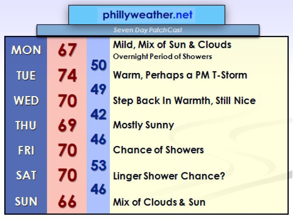
Temperatures reached 70 last Thursday for the first time since last November in the area. If you liked that tease of spring warmth, this week will be a several course spread of May-like warmth, along with spring-like thunderstorms possible on Tuesday and again Friday.
For those of us with short memories, 80-degree weather has and does occur in March from time to time, most recently in 2007. Just a couple of days before the "Ice of March," also known as the St. Patrick's Day sleetstorm.
You don't need to be Shakespeare to wax poetic about how cruel and fickle March weather can be and all it takes is a rogue cool front sneaking in off the Atlantic to turn shorts weather into dreary drizzle and clouds. While the coming week features significant warmth, it may be muted this weekend a bit with the presence of a cool front that pushes through on Friday night into Saturday with shower and thunderstorm chances.
Find out what's happening in West Chesterwith free, real-time updates from Patch.
Some of the computer modeling out there is trying to stall the front out nearby, which may mean some drear extends into Sunday and being on the cool side of the front would result in temperatures lower than progged a week in advance.
However, between now and then the week ahead should feature some rather nice weather on the whole with one other exception. Monday night and Tuesday features a disturbance pushing through the region with showers and thunderstorms in two rounds - the first on Monday night, the second on Tuesday afternoon. The second round would probably bring the better chances of thunderstorms to the region. Severe isn't anticipated but a few rumbles of thunder can't be ruled out.
Find out what's happening in West Chesterwith free, real-time updates from Patch.
High temperatures could be their highest this week on Tuesday - potentially reaching or breeching 75 degrees in the suburbs. It wouldn't surprise if some upper-70s were on the optimistic bank thermometers around town. Wednesday and Thursday may be a touch less warm than Tuesday but should hit or flirt with 70 either day with mostly sunny skies.
I alluded to the point about how it can hit 80 around here in March - the record highs for this time of the year in Philly and Reading are in the 80s from warm waves that hit the region in 1990 and 1945, respectively. Even though it will be about 15 to 20 degrees warmer than average on many days this week, record heat is unlikely. You can still fire up the grill most days this week and enjoy the warmth though!
====================================================
Tom Thunstrom is the editor and publisher of Phillyweather.net. You can follow the site on twitter @phillywx.